The Queensland Regional Planning Interests Act has loopholes they are driving drilling rigs through and there are major lessons for Lake Eyre Basin and others that should be learned from the experiences on the Darling Downs.
As seen recently within days of each other in early February 2020, there were numerous news articles[1] relating to strong concerns over the Queensland State Government’s approach to planning in regional and rural Queensland generally, but in particular concerns relating to areas such as the Lake Eyre Basin and Wide Bay / Burnett resource activity proposals and a new map showing the percentage of the state with conflicting land uses.
These concerns are certainly valid, but the points that these articles appear to miss are that these issues are not new and statistics alone are not enough to remedy the problem. The major problems with the RPI Act were raised in 2013 at the introduction of the Regional Planning Interests Bill by the people featured in these recent articles and others in detailed submissions registering concerns to the committee investigating the 2013 Bill. Frustratingly, their fears as detailed, have indeed come to pass in the intervening years since the enactment of the Regional Planning Interests Act.
The recent calls for a ‘review of the legislation’ and renewed concern over poor consultation are potentially missing the opportunity to use real examples of failure in the foundation and purpose of the RPI and failures to address significant issues in 2013 drafting and enactment of the Bill. Doing so would ensure these issues are not repeated and real and successful changes are made that will actually achieve the needs of these stakeholders instead of allowing a continuation of the relentless repetitive roll out of the same government rhetoric that ultimately results in them giving primacy to resource companies over environmental and agricultural areas. (A position that is reinforced by the Queensland Audit Office recent report 18/2/20)[2]
The Regional Planning Interests Act (RPI Act) does not need a mere superficial review. A complete reset is needed to correct flaws right down to the RPI Act’s very foundations to be able to genuinely deliver its supposed purpose:
“The Queensland Government’s Regional Planning Interests Act (RPI Act) will deliver on the government’s commitment to protect prime agricultural land and provide greater power to landholders in negotiating with resource companies..” [3]
The Darling Downs has already experienced the injustices feared in these articles
The foundations of the RPI Act go down to the Regional Plans. In October 2013 when Jeff Seeney (the then LNP Deputy Premier and Minister for State Development, Infrastructure and Planning) took the strategic opportunity to develop the Darling Downs Regional Plan and embed the Government’s planning reform agenda. Establishing priority agricultural land and gas industry coexistence criteria enabling the formula for similar plans to be rolled out across Queensland in the years to come. The Darling Downs Regional Plan (closely followed by the Central Queensland Regional Plan) was a road map for the introduction of the Regional Planning Interests Bill 2013 that was introduced the following month (November 2013) and the regional plans to follow. Unsurprisingly, the Darling Downs and the Central Queensland Regional Plans happened to be the focus of the developing CSG export industry and these new regional plans were blatant in their paving of the way for the gas industry at the expense of other planning scenarios that should have been considered.
Since 2013 on the Downs there are have been many instructive examples of how what was feared (and detailed in those early submissions), has come to pass, directly as a result of the RPI Act. The harsh experiences of the Darling Downs would be instructive for the Lake Eyre Basin, Agforce, Lock the Gate and the east coast regions such as Wide Bay/ Burnett to use in protecting themselves from the same fate as the Darling Downs and Central Queensland. Examples are detailed in the cases at the following web site: www.molliwell.com.au/regional_planning_interests_act .
Until recently, on the Darling Downs, the expectations of the families and small agribusinesses required to host the gas industry (like those in the Lake Eyre Basin, Northern Territory and New South Wales) would have been that the government would make decisions on legislation that would protect the common good such as the future of food and water security and areas of environmental and cultural significance. On the contrary, these residents have found themselves subject to gas industry imposition with nearly no rights, remedies or protections in place as a direct result of the Regional Interests Planning Act 2014 and other resource related legislation
Communities, landowners & business owners facing recent industry proposals and plans would benefit from investigating and using as evidence today what the past has shown as failure of government.
The re-engineering of the regulatory environment around the development of the gas industry has meant that directly by design of the Regional Planning Interests Act, that right now these farming families find themselves living within a few hundred metres of heavily industrialised gas infrastructure such as compressor stations, salt dumps, water treatment facilities, electrical sub stations, battery banks, carbon injection and storage trials, and solar farms.
[1] http://www.dlgrma.qld.gov.au/resources/factsheet/planning/rpi-act-agricultural-sector.pdf
A https://www.queenslandcountrylife.com.au/story/6612425/producers-seek-further-detail-on-basin-plan/#
D https://www.thefifthestate.com.au/articles/nsw-can-have-water-or-fossil-fuels-but-not-both/
[2] [QAO recommends government] reviews the assessment process identified under the Regional Planning Interests Act 2014 to determine whether the process adequately manages coal seam gas activities in areas of regional interest. This should take into consideration stakeholders’ concerns about inconsistent definitions of land and exceptions to the assessment process
[3] http://www.dlgrma.qld.gov.au/resources/factsheet/planning/rpi-act-agricultural-sector.pdf
CASE 1 – Priority Living Areas
The definition of priority living area (PLAs) did not expressly prevent resource activities occurring within these designated areas. Queensland Resources Council insisted that keeping flexibility in the definition and implementation of Priority Living Areas (PLAs) in the Regional Planning Interests Act would help communities ‘realise the real value of resources projects’[3].
Needless to say the definition of PLAs remained flexible and after a 2015 application to the Western Downs Regional Council to establish a PLA for a rural residential estate near Tara to protect them from encroachment from the gas industry, the council finally in 2017 perversely denied the application without explanation but presumably to assist the community to ‘realise the real value of the gas industry to them’.
[3] Glencore, Submission No. 56
CASE 2 – Coexistence & Exemptions
The purpose of the legislation was to manage the coexistence of resource activities and highly productive agricultural activities, yet there was no definition of the term “coexistence” and it was used only once in the Act, in the description of the purpose of the legislation. The Deputy Premier defended this at the time by saying that ‘[t]he best example of coexistence is when a landholder and a resource company both voluntarily agree’.
The government committee undertook site visits to two feedlots in the Chinchilla region to discuss coexistence with landholders and representatives from resource companies. The committee saw an example of a property where both the landholder and the resource company considered that coexistence had been achieved. At the second property, the landholders expressed disquiet about the presence of miners on their land due to disruption of their lifestyle and negative impacts on their business [1]
The department responsible for the Bill relied on the following: The concept or philosophy of co-existence permeates through the provisions of the Bill. It is reflected through the purpose of the Bill, the recognition and definition of the areas of regional interest, and the establishment of a process that requires resource activities and other regulated activities to make an application supported by information that demonstrates how the proposal achieves the requirements of the relevant assessments.
The significant problems here being that a Compensation and Conduct Agreement (CCA) is not a voluntary agreement, since the landholder has no statutory right to refuse the land access contract, and the resource company is exempted from undertaking the application if they had an authority to undertake the activity pre-dating the RPI Act (which is a huge proportion of the Darling Downs).
This did not help the Hopeland area near Chinchilla, a priority agricultural area. Another legacy of the Linc contamination, underground coal gasification was permitted to occur in the area prior to the RPI Act, and then despite the evolving contamination incident, Origin Energy were permitted under the RPI Act to proceed with their activities because they had a pre-existing EA for the activity. Therefore, the requirement for them to assess the impact their activities would have on the priority agricultural land given the special circumstances and the chances of it effecting the existing contamination (a very sensible purpose of the legislation) was not required.
[1] Regional Planning Interests Bill 2013 Report No. 35 State Development, Infrastructure and Industry Committee March 2014
CASE 3 – Selective Regional Planning Interests Application Process
Arrow Energy, operating in the same contaminated Hopeland area, was only required to enter into a Regional Planning Interests Development Application (RIDA) on one property in the activity area because it owned that property. Arrow had otherwise intended to enter into ‘agreements’ with the other landholders in the area and was able to flout the legislation through the following:
Arrow RIDA application for 2 groundwater monitoring bores to be placed on property owned by Arrow within PL 253, right next to the Linc contamination source site.
- Nowhere in their application do they mention the need to have the monitoring bores in place as a result of the requirements of their EA (conflicting as they may be).
- Nowhere is the Linc contamination source site discussed, only a reference to the lot and plan number of the property is made.
- Nowhere is there an assessment of what putting the monitoring bores in will do to the contamination (Linc’s own water monitoring bores have been proven to be a pathway for the contamination).
- Nowhere in the application is the supposed 2018 Arrow modelling and assessment document required by the EA referred to.
- No further impact of their activities is assessed due to the ridiculously circuitous and useless loophole in the legislation and application process that allows them to assert they INTEND to get CCAs with landholders (who are not yet identified and will therefore have no ability to influence this application decision, when the reality is the potential to mobilise and make worse the contamination from Linc is a very real issue that should be an overt and transparent assessment process in an attempt to protect priority agricultural land)
- Section 1.4 in the Arrow application states that they have safely and sustainably produced CSG, this statement is unfounded and not proven. It has the effect of influencing the assessment without any actual data to prove it.
- Section 1.5 again makes unfounded assertions and absolutely lacks any feedback from those supposedly “coexisted” with. It makes the application process circuitous and self-fulfilling.
- Section 1.6 discusses area wide planning that has not been undertaken and again is an example of the useless circuitous process whereby the impacted landholders are not represented or consulted until after the fact. In this specific application, the consultation and technical details which they refer to in the last paragraph in this section is absurd and further highlights the tick and flick process of the assessment as it refers to them having undertaken this consultation and a CCA process with themselves. Arrow are both the landholder and the applicant.
- Section 2.1 their description of the works assiduously avoids openly and transparently describing the very specific reason for the groundwater monitoring program – the Linc contamination, therefore any impact of the contamination is not taken into consideration in the assessment of the application.
- It does not give any discussion or evidence as to how Arrow have previously assessed this activity will not impact or exacerbate the existing Linc contamination nor how it will into the future and therefore in assessing the RIDA. None of that will be considered. The application fails to identify the need for baseline testing prior to undertaking the activity to identify any further interaction with the contamination to the soil, surface water etc.
- Section 2.3.2 describes the CSG activities in primacy and fails to recognise the original and more important primary use of the land, limiting the adequate assessment of the application.
- Section 2.4 fails to indicate the important interactions with PL 493 and subsequent EA conditions with this PL and EA limiting the meaningful assessment of the application.
- Section 3.1.3 asserts that Priority Agricultural Land Use (PALU) does not apply to the property because the property has not been used for PALU for at least 3 of the previous 10 years. This is an inaccurate representation because for 5 of the last 10 years Arrow themselves have owned the property, and by the nature of their business PALU is not their core activity and therefore not their interest. This again prevents a true assessment of the application (which in itself is an additional problem with the legislation, because the significant purchasing of land in the area by the CSG industry means that the original priority use of the land and the intent of the legislation is skewed due to the encroachment of the industry and lack of representation of the farmers in the process).
The framing of this criteria means that the resource sector can simply buy prime agricultural land and sit on it without using it as PALU – avoiding the criteria and changing the use of the agricultural land. This is an unacceptable outcome for Queensland’s precious agricultural land. - The application fails to identify the how the impact of the chain of responsibility amendments will influence their activities given the existing contamination.
- The maps, Environmental Authorities, Petroleum Leases, land parcels and descriptions rely on surface land parcels and boundaries but do not acknowledge that the source of the contamination is underground and does not show that underground source in relation to the proposed groundwater monitoring or other CSG activities therefore this cannot be a reasonable assessment.
CASE 4 – Cumulative Impacts & gaps with other regulations
In the case of Senex Energy Atlas Project near Wandoan, several large pieces of infrastructure have been placed (or are planned for imminent construction) on Strategic Cropping Land (a Compressor Station, an aggregation dam, water treatment facility and major pipeline).
This project and infrastructure did not need a Regional Planning Interests Act Approval since Senex would get ‘agreement’ via Conduct and Compensation Agreements with landholders for their infrastructure. This loophole further exacerbates the resultant unconsidered impacts such infrastructure has on the neighbours who are subsequently shut out of the process but whose property values, lifestyles and business are impacted. They are now left as individuals to impotently chase resource companies to engage with them with no formal remedy.
The water treatment facility did not need an Environmental Impact Statement because the original Environmental Authority was for a project that was smaller than the trigger size for an environmental impact assessment. The company then leveraged the original Environmental Authority with an amendment for the larger water treatment facility. The industry tool of adaptive management allows unacceptable proposals to sneak through.
The major pipeline did not need an Environmental Impact Statement since it was less than 300km long (292 km).
Despite this project being one of several significant projects with large infrastructure in the immediate area, (Origin, APLNG, Shell QGC and CTS Carbon Capture as shown below), there is no constraint implemented for any of the projects on the basis of cumulative impacts. The Environment Department uses information through the state and regional planning authorities to help trigger the need for an environmental impact statement where there may be a cumulative impact. However, if the planning act allows the resource companies to avoid much of the administrative process, this means the other regulatory tool are missing out on valuable decision making data. Again demonstrating the failure of either act to have any meaningful impact individually or in combination.
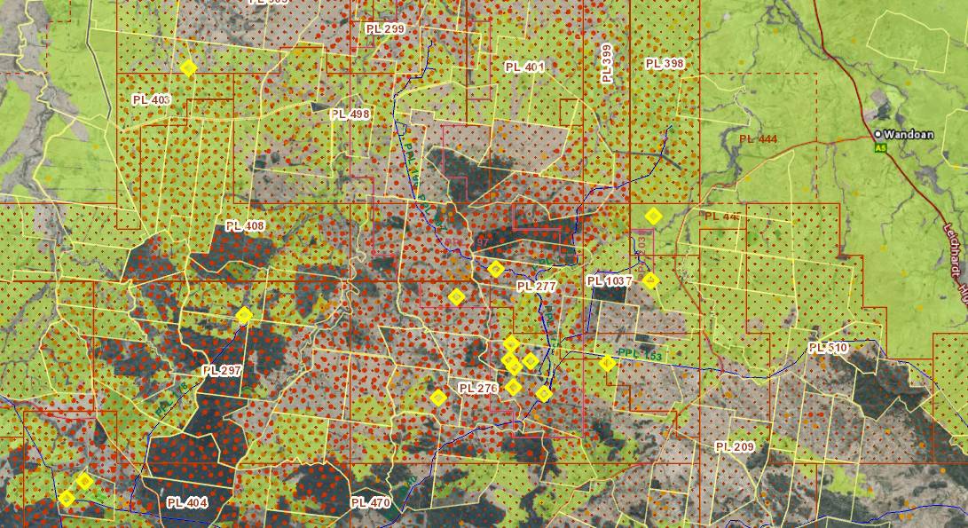
Strategic Cropping land in light green, large red and orange dots are gas wells, red squares are petroleum leases, yellow diamonds are large CSG infrastructure such as Compressor Stations and water treatment facilities, yellow lines are boundaries of peoples properties.

Wolleebee CSG infrastructure.
CASE 5 – Peak body capture, advocacy vs inertia
Peak bodies such as Agforce run a very fine line between advocacy for their members and inertia/impotency when trying to please two masters.
Adding to the irony is that despite Agforce’s apparent dismay – demonstrated in the cited articles from this week, they were in fact representatives on the fateful Darling Downs Regional Planning Committee 2012; they were sent direct consultation copies on the RPI Bill 2013; they were then financially engaged with the imposition of the gas industry on rural families for the next 5 years through the CSG Project which was delivered by AgForce with the support of the Queensland Government, the Australian Petroleum Production and Exploration Association, Queensland Resources Council and the GasFields Commission Queensland (this was inexplicably suspended in 2018).
Peak bodies such as Agforce must remain staunchly protective of the people and concerns they represent in such fundamental, sweeping and enduring legislative conflicts. Comments quoted from Agforce in recent articles also demonstrate the failure of such bodies to pick a side and hence they weaken representation of their members. Comments such as: AgForce Queensland Chief Executive Michael Guerin said… “While mining and energy development did offer opportunities for regional communities, it was ‘vital’ governments ensured agricultural land was not taken out of production by ‘poorly conceived legislation’.”
Such peak bodies must identify that the legislation does not require ‘review’. The real outcomes and lived experience of the enactment of the legislation must be held up and examined thoroughly to ensure real and successful changes are made and flaws in the foundation and purpose of the legislation are remedied.